



Admiralty - ADLL zone 8 - Liste des feux et signaux de brume
search
  • googlemap
  • Admiralty - ADLL zone 8 - Liste des feux et signaux de brume

Admiralty - ADLL zone 8 - Liste des feux et signaux de brume

€138.85
Tax included
Admiralty - United Kingdom Hydrographic Office
Chart or book in digital version In English language In French language
Book programmed to order
Estimated preparation time: 0 to 3 days

Essential digital guide for navigators covering over 85,000 light structures and fog signals in the Pacific, New Zealand, and the Americas' western coasts. Updated weekly for accuracy.

CDR565-8

Data sheet

Who is the publisher or the author?
Admiralty
On what digital medium is this nautical chart / book stored?
digital medium
download
From which year does this nautical chart date?
2017 / 2018
What type of navigation book is this?
guide to fog lights and signals
Picto
Chart or book in digital version
In English language
In French language

Specific References

UPC
400000134628
EAN13
4000000105343
New
Book programmed to order
Description détaillée

ADLL Zone 8 – Digital List of Lights and Fog Signals

Publication in English
Digital publication readable only on PC with Windows 7 and later versions

Comprehensive Navigation Aid for the Pacific and Beyond

Navigate the vast waters of the Pacific Ocean, New Zealand, and the western coasts of North and South America with confidence. This digital guide delivers precise, up-to-date information on over 85,000 light structures, including lighthouses, lighted beacons (over 8 meters tall), fog signals, and other navigational lights. Designed for mariners who demand accuracy, it ensures safe passage through some of the world’s most critical maritime routes.

Precision Data for Safe Navigation

  • Each entry includes the international number, exact location, and geographic coordinates for effortless identification.
  • Detailed characteristics such as light intensity, elevation, and nominal range in nautical miles help you plan your voyage with precision.
  • Structural descriptions provide visual confirmation, while tables allow for quick calculations of geographic and luminous ranges.
  • Multilingual descriptions ensure clarity, even in foreign waters.

Optimized for Digital Use

  • Compatible exclusively with PCs running Windows 7 or later, this digital format offers seamless integration with your navigation systems.
  • Weekly updates via Admiralty Notices to Mariners keep you informed of the latest changes, ensuring your data is always current.
  • Unlike paper versions, this digital edition covers a broader geographic scope, making it ideal for long-haul voyages.

Why Choose This Digital Guide?

  • Trusted by professional mariners for its reliability and depth of information.
  • Eliminates the need for bulky paper charts, streamlining your navigation setup.
  • Annual licensing ensures you receive continuous updates and support throughout your subscription.
  • Downloadable format allows for quick installation, so you can get underway without delay.

Essential for Modern Mariners

Whether you're a commercial captain, a long-distance sailor, or a maritime professional, this digital guide is an indispensable tool for navigating the Pacific and its surrounding waters. Stay ahead of the curve with accurate, accessible, and actionable data—wherever your journey takes you.

Navigate the Pacific with Unmatched Precision
This digital guide is your ultimate companion for safe and efficient navigation across the Pacific Ocean, New Zealand, and the western coasts of the Americas. Covering over 85,000 light structures, including lighthouses, lighted beacons, and fog signals, it provides mariners with the most accurate and up-to-date information available. Designed for professionals who refuse to compromise on safety, this tool ensures you have the critical data needed to make informed decisions at sea.

Data You Can Trust, Wherever You Sail
Every entry in this guide is meticulously detailed, offering the international number, exact location, and geographic coordinates of each light structure. You’ll find essential specifications such as light intensity, elevation, and nominal range in nautical miles, allowing you to calculate visibility and plan your route with confidence. Structural descriptions and multilingual support further enhance usability, ensuring clarity no matter where your voyage takes you.

Built for the Digital Age
Say goodbye to cumbersome paper charts. This digital guide is optimized for PCs running Windows 7 or later, offering seamless integration with your navigation systems. Weekly updates via Notices to Mariners keep your data current, while the annual licensing model ensures you always have access to the latest information. The downloadable format means you can install it quickly and get underway without delay, making it the perfect choice for modern mariners.

Tailored for Professionals
Whether you're navigating commercial shipping lanes, planning a long-distance voyage, or ensuring the safety of your crew, this guide is designed to meet the demands of professional mariners. Its comprehensive coverage and user-friendly interface make it an indispensable tool for anyone sailing the Pacific and its surrounding waters. Equip yourself with the best—because at sea, precision isn’t just important, it’s everything.

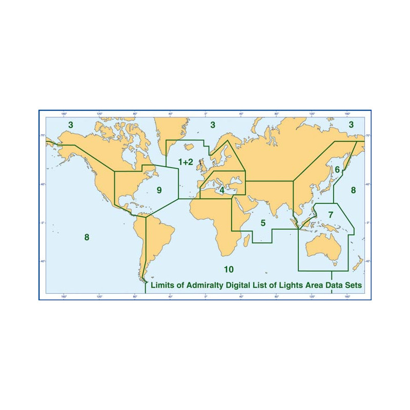
This digital guide covers Zone 8, encompassing the Pacific Ocean, New Zealand, and the western coasts of North and South America. It includes over 85,000 light structures, with weekly updates to ensure accuracy. Compatible with Windows 7 and later versions, it offers an annual license and is available for instant download. Geographic coverage spans latitudes from 67°N to 80°S and longitudes from 143°E to 177°W, providing comprehensive data for safe navigation in these critical waters.

For over two centuries, this organization has been the gold standard in maritime navigation, providing mariners worldwide with reliable, accurate, and up-to-date nautical information. Their publications are trusted by commercial fleets, naval forces, and recreational sailors alike, ensuring safety and efficiency at sea. With a commitment to innovation, they continue to lead the way in digital navigation solutions, setting the benchmark for the industry.

  • This digital guide offers unparalleled accuracy with over 85,000 light structures meticulously documented, ensuring you have the most reliable data for safe navigation.
  • Weekly updates keep your information current, while the digital format eliminates the need for bulky paper charts, streamlining your navigation setup.
  • Compatible with Windows 7 and later, it integrates seamlessly with your existing systems, and the annual licensing model guarantees continuous access to the latest data.
  • Multilingual support and precise geographic coverage make it an indispensable tool for mariners navigating the Pacific and beyond.
What regions are covered in this digital guide?

This guide covers the Pacific Ocean, New Zealand, and the western coasts of North and South America.

What types of navigational aids are included in this guide?

It includes lighthouses, lighted beacons over 8 meters tall, fog signals, and other navigational lights.

What details are provided for each navigational aid?

Each entry includes the international number, location, geographic coordinates, characteristics, intensity, elevation, range in nautical miles, and a description of the structure.

How often are updates provided for this digital guide?

Updates are provided weekly through Notices to Mariners.

What are the system requirements for using this digital guide?

It is compatible with PCs running Windows 7 and later versions.

How many light structures are covered in this guide?

The guide covers over 85,000 light structures.

Is this digital guide available in multiple languages?

Yes, it is available in English and French.

Loading...