



Admiralty - ADLL zone 7 - Liste des feux et signaux de brume
search
  • googlemap
  • Admiralty - ADLL zone 7 - Liste des feux et signaux de brume

Admiralty - ADLL zone 7 - Liste des feux et signaux de brume

€138.85
Tax included
Admiralty - United Kingdom Hydrographic Office
Chart or book in digital version In English language In French language
Book programmed to order
Estimated preparation time: 0 to 3 days

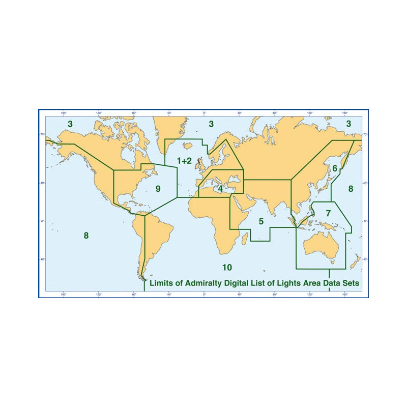
Zone 7’s digital List of Lights and Fog Signals covers 85,000+ navigation aids across Australia, Borneo, and the eastern Philippines. Updated weekly for precision.
For Windows PCs only.

CDR565-7

Data sheet

Who is the publisher or the author?
Admiralty
On what digital medium is this nautical chart / book stored?
digital medium
download
From which year does this nautical chart date?
2015 / 2016
What type of navigation book is this?
guide to fog lights and signals
Picto
Chart or book in digital version
In English language
In French language

Specific References

UPC
400000134635
EAN13
4000000105336
New
Book programmed to order
Description détaillée

ADLL Zone 7 – List of Lights and Fog Signals

Publication in English
Digital publication readable only on PC with Windows 7 and later versions

Unmatched Precision for Safe Navigation in the Pacific and Southeast Asia

Navigate the waters of Australia, Borneo, the eastern Philippines, and the broader Pacific and Southeast Asian regions with confidence. This digital publication delivers an exhaustive database of over 85,000 navigation lights, lighthouses, lightships, illuminated floating marks, and fog signals, ensuring you have the most critical information at your fingertips. Designed for mariners who demand accuracy and reliability, this tool is indispensable for voyage planning, real-time navigation, and compliance with international maritime standards.

Why Choose a Digital Navigation Guide?

  • Comprehensive Coverage: Detailed entries for every light and fog signal in Zone 7, including characteristics, intensity, elevation, geographic and luminous range, coordinates, and structural descriptions.
  • Up-to-Date Information: Stay ahead with weekly updates via Admiralty Notices to Mariners, ensuring your data reflects the latest changes in navigational aids and hazards.
  • Seamless Integration: Compatible with ECDIS, ECS, ARCS, and voyage planning software, allowing for smooth incorporation into your existing navigation systems.
  • Multilingual Support: English descriptions with equivalent foreign language translations, making it accessible for international crews.
  • Trusted by the Industry: Approved by flag states representing over 80% of internationally trading vessels, this publication meets the highest standards for maritime safety.

Designed for Modern Mariners

This digital edition is tailored for professionals who rely on cutting-edge technology to enhance safety and efficiency. Whether you're navigating coastal waters, busy shipping lanes, or remote regions, this guide provides the clarity and detail needed to make informed decisions. Its user-friendly interface and robust search capabilities allow for quick access to critical data, reducing the risk of errors and improving operational workflows.

Reliability You Can Count On

Backed by decades of maritime expertise, this publication is a cornerstone for safe navigation. It eliminates the need for cumbersome paper charts and manual updates, offering a streamlined, eco-friendly solution that keeps pace with the demands of modern shipping. With an annual license, you ensure continuous access to the most current and accurate navigational data available.

Optimized for Performance

Compatible with Windows 10+ and macOS 10.15+, this digital guide requires minimal storage (500 MB of free space) and delivers maximum efficiency. The dataset, approximately 150 MB in size, is optimized for fast loading and smooth operation, even in low-bandwidth environments. Whether you're on a commercial vessel, a research ship, or a private yacht, this tool adapts to your needs.

Your Partner in Safe and Efficient Navigation

From the bustling ports of Australia to the remote islands of the Pacific, this digital guide is your trusted companion for navigating one of the world's most dynamic maritime regions. Invest in precision, reliability, and peace of mind with a tool designed to meet the challenges of modern navigation.

Navigate with Confidence Using the ADLL Zone 7 Digital List of Lights and Fog Signals
Sail through the complex waters of Australia, Borneo, the eastern Philippines, and the Pacific with unparalleled precision. This digital navigation guide is your ultimate resource for over 85,000 critical navigational aids, including lighthouses, lightships, illuminated buoys, and fog signals. Designed for mariners who refuse to compromise on safety or accuracy, this tool provides real-time, detailed data to support every phase of your voyage—from planning to execution.

Engineered for the Demands of Modern Maritime Operations
This digital publication is more than just a database—it’s a lifeline for mariners navigating one of the world’s most trafficked and diverse maritime regions. Covering latitudes from -48° to 21.5° and longitudes from 105° to 168°, it delivers comprehensive coverage of Zone 7, ensuring no critical detail is overlooked. Each entry includes essential specifications such as light characteristics, intensity, elevation, geographic and luminous range, precise coordinates, and structural descriptions, giving you the clarity needed to make informed decisions in real time.

Stay Ahead with Weekly Updates and Seamless Integration
Maritime conditions change rapidly, and so should your navigational tools. This guide is updated weekly via Admiralty Notices to Mariners, ensuring your data is always current and compliant with the latest international standards. Compatible with ECDIS, ECS, ARCS, and voyage planning software, it integrates effortlessly into your existing systems, reducing downtime and enhancing operational efficiency. Whether you’re navigating coastal waters or open seas, this tool adapts to your needs, providing reliable support in even the most challenging environments.

Built for Professionals, Trusted by the Industry
Approved by flag states representing over 80% of internationally trading vessels, this digital guide is a benchmark for maritime safety. Its multilingual support—offering English descriptions with equivalent foreign language translations—ensures accessibility for international crews, while its user-friendly interface allows for quick and intuitive searches. With an annual license, you gain continuous access to the most accurate and up-to-date navigational data available, eliminating the hassle of manual updates and paper charts.

Optimized for Performance and Reliability
Designed to perform under pressure, this digital guide requires just 500 MB of free space and is compatible with Windows 10+ and macOS 10.15+. The dataset, approximately 150 MB in size, is optimized for fast loading and smooth operation, even in low-bandwidth conditions. Whether you’re on a commercial vessel, a research ship, or a private yacht, this tool delivers the reliability and precision you need to navigate with confidence.

This digital navigation guide provides an exhaustive database of over 85,000 navigational aids, including lights and fog signals, covering Zone 7—Australia, Borneo, the eastern Philippines, and surrounding Pacific and Southeast Asian regions. Updated weekly via Admiralty Notices to Mariners, it ensures compliance with the latest maritime standards. Compatible with ECDIS, ECS, ARCS, and voyage planning software, it operates on Windows 10+ and macOS 10.15+, requiring 500 MB of free space. The dataset, approximately 150 MB, includes detailed entries for light characteristics, intensity, elevation, range, coordinates, and structural descriptions, all accessible through a user-friendly interface.

With a legacy spanning over two centuries, this publisher is a global leader in maritime navigation, providing trusted and authoritative hydrographic data to mariners worldwide. Renowned for its commitment to accuracy, innovation, and safety, its publications are the gold standard for commercial and recreational navigation, ensuring vessels of all sizes can operate with confidence in any waters.

  • This digital navigation guide offers unmatched precision with over 85,000 detailed entries for lights and fog signals, ensuring you have the most critical data at your fingertips. Its weekly updates via Admiralty Notices to Mariners guarantee compliance with the latest maritime standards, while seamless integration with ECDIS, ECS, and voyage planning software enhances operational efficiency. Multilingual support and a user-friendly interface make it accessible for international crews, and its compact 150 MB dataset ensures fast, reliable performance even in low-bandwidth conditions. Trusted by over 80% of internationally trading vessels, it’s the ultimate tool for safe and efficient navigation in Zone 7.
What operating systems are compatible with this digital publication?

This digital publication is compatible with Windows 10 or later and macOS 10.15 or later.

How often are updates provided for this publication?

Updates are provided weekly via the Admiralty Notices to Mariners, with major updates released six times a year (weeks 13, 19, 25, 31, 37, and 43).

What is the storage requirement for installing this digital publication?

The installation requires approximately 500 MB of free storage space.

Does this digital version cover the same area as the paper edition?

No, this digital version does not cover exactly the same area as the paper editions.

What types of navigation aids are included in this publication?

It includes detailed information on over 85,000 navigation lights, lighthouses, lightships, floating illuminated marks, and fog signals.

Is this publication compatible with ECDIS systems?

Yes, it is compatible with ECDIS, ECS, ARCS, and voyage planning software.

What languages are available in this digital publication?

The publication is available in English, with equivalent descriptions in foreign languages.

Loading...