



Admiralty - Zone ADLL 1 + 2 - Liste des feux et signaux de brume
search
  • googlemap
  • Admiralty - Zone ADLL 1 + 2 - Liste des feux et signaux de brume

Admiralty - Zone ADLL 1 + 2 - Liste des feux et signaux de brume

€138.85
Tax included
Admiralty - United Kingdom Hydrographic Office
Chart or book in digital version In English language In French language
Book programmed to order
Estimated preparation time: 0 to 3 days

Navigate global waters with precision using this digital guide covering over 85,000 navigation lights and fog signals for Zones 1 & 2. Updated weekly for accuracy.

CDR565-1-2

Data sheet

Who is the publisher or the author?
Admiralty
On what digital medium is this nautical chart / book stored?
digital medium
download
From which year does this nautical chart date?
2015 / 2016
What type of navigation book is this?
guide to fog lights and signals
Picto
Chart or book in digital version
In English language
In French language

Specific References

UPC
400000134680
EAN13
4000000108948
New
Book programmed to order
Description détaillée

ADLL Zones 1 & 2 – Digital List of Lights and Fog Signals

Publication in English
Digital publication readable only on PC with Windows 7 and later

Unmatched Precision for Safe Navigation

Navigate with confidence using the most comprehensive digital reference for over 85,000 navigation lights and fog signals across Northern and Western Europe, Northwest Africa, and Atlantic regions. Designed for mariners who demand accuracy and reliability, this digital publication delivers real-time data to ensure safe passage through some of the world’s busiest and most complex waterways.

Why Choose a Digital Navigation Guide?

  • Instant Access to Critical Data: No more flipping through pages—search, filter, and retrieve information on lighthouses, lighted buoys, fog signals, and more with just a few clicks.
  • Weekly Updates for Unmatched Accuracy: Stay ahead of changes with automatic updates via Notices to Mariners, ensuring your data is always current and compliant with the latest maritime regulations.
  • Optimized for Professional Use: Tailored for ship officers, navigators, and maritime professionals, this tool integrates seamlessly into your onboard systems, reducing manual errors and saving valuable time.
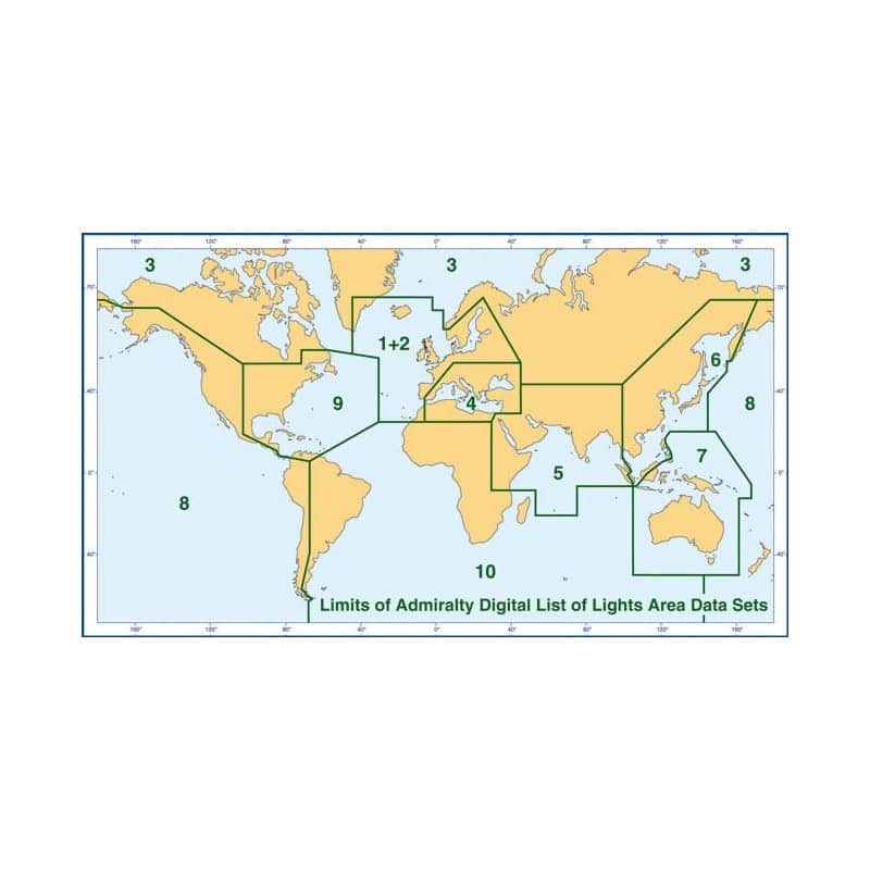
  • Global Coverage, Local Precision: Focused on Zones 1 and 2, this guide provides detailed insights into high-traffic areas, including the English Channel, North Sea, Baltic Sea, and Atlantic coastlines, where accurate navigation is non-negotiable.

Key Features for Modern Mariners

  • Comprehensive Light Characteristics: Access detailed descriptions of light patterns, colors, intensities, and ranges, along with structural details of lighthouses and lighted marks.
  • Multilingual Support: Navigate with ease thanks to descriptions available in both English and French, ensuring clarity across international crews.
  • Advanced Search and Filtering: Quickly locate specific lights or signals by name, location, or characteristics, streamlining your route planning and execution.
  • Geographic and Luminous Range Calculations: Utilize built-in tables to calculate visibility ranges based on your vessel’s height and prevailing conditions, enhancing situational awareness.
  • Seamless Integration: Compatible with Windows 10 and 11, this digital guide is designed to work alongside your existing navigation software, providing a cohesive and efficient workflow.

Built for the Demands of Modern Navigation

Whether you’re navigating congested shipping lanes, planning a transatlantic voyage, or ensuring compliance with maritime safety standards, this digital guide is your trusted companion. It eliminates the guesswork from nighttime and low-visibility navigation, allowing you to focus on what matters most—safely reaching your destination.

Who Should Use This Guide?

  • Commercial Mariners: Ensure compliance with SOLAS regulations and maintain the highest standards of safety for crew and cargo.
  • Recreational Sailors: Navigate coastal waters and offshore routes with the same level of precision as professional mariners.
  • Maritime Training Institutions: Equip students with the tools they need to master navigation in real-world conditions.
  • Port Authorities and Pilots: Access reliable data to guide vessels safely into harbors and through narrow passages.

Stay Ahead of the Curve

In an industry where conditions change rapidly, relying on outdated or incomplete information can have serious consequences. This digital guide ensures you’re always equipped with the latest data, giving you the edge in safety, efficiency, and compliance. Download it today and experience the future of maritime navigation.

Navigate with Confidence Using the Ultimate Digital Guide to Navigation Lights and Fog Signals
When precision and reliability are non-negotiable, the ADLL Zones 1 & 2 – Digital List of Lights and Fog Signals stands as the gold standard for mariners worldwide. This advanced digital publication provides instant access to over 85,000 navigation lights and fog signals, covering critical regions such as Northern and Western Europe, Northwest Africa, and the Atlantic. Designed for professionals who demand the highest level of accuracy, this tool ensures safe and efficient navigation through some of the world’s most challenging waterways.

Engineered for Modern Maritime Operations
Gone are the days of cumbersome paper charts and manual updates. This digital guide is optimized for Windows 10 and 11, offering a seamless and intuitive experience for ship officers, navigators, and maritime professionals. With weekly updates delivered via Notices to Mariners, you can trust that your data is always current, compliant, and ready for action. The guide’s advanced search and filtering capabilities allow you to locate specific lights or signals in seconds, whether you’re planning a route or navigating in real-time.

Comprehensive Data for Unmatched Situational Awareness
Every entry in this digital guide is packed with critical details to enhance your navigation strategy. From the characteristics of light patterns—such as color, intensity, and flash sequences—to the structural descriptions of lighthouses, lighted buoys, and fog signals, no detail is overlooked. Built-in tables for calculating geographic and luminous ranges provide additional layers of precision, allowing you to assess visibility based on your vessel’s height and prevailing conditions. Multilingual support in English and French ensures clarity across international crews, making it an indispensable tool for global operations.

Built for the Rigors of Professional Navigation
Whether you’re navigating congested shipping lanes, planning a transatlantic voyage, or ensuring compliance with maritime safety standards, this digital guide is designed to meet the demands of modern navigation. It eliminates the guesswork from nighttime and low-visibility operations, allowing you to focus on safely reaching your destination. Compatible with your existing navigation software, it integrates effortlessly into your workflow, enhancing efficiency and reducing the risk of human error.

This digital guide covers Zones 1 and 2, encompassing Northern and Western Europe, Northwest Africa, and Atlantic regions, with detailed data on over 85,000 navigation lights and fog signals. Designed for Windows 10 and 11, it offers weekly updates via Notices to Mariners, ensuring your information is always current. The guide includes comprehensive details such as light characteristics, structural descriptions, geographic and luminous range calculations, and multilingual support in English and French. With a file size of approximately 500 MB, it provides instant access to critical navigation data, streamlining route planning and execution.

With a legacy spanning over two centuries, this publisher is a global leader in hydrographic and maritime data solutions. Renowned for its commitment to accuracy, innovation, and safety, it provides essential tools and publications that empower mariners, naval forces, and maritime organizations worldwide. Its products are trusted by professionals for their reliability, precision, and adherence to the highest industry standards, making them indispensable for safe and efficient navigation.

  • This digital guide offers unparalleled convenience and reliability for mariners, combining instant access to over 85,000 navigation lights and fog signals with weekly updates to ensure data accuracy. Its advanced search and filtering capabilities streamline route planning, while built-in range calculation tools enhance situational awareness. Designed for seamless integration with existing navigation systems, it reduces manual errors and saves valuable time, making it an essential tool for safe and efficient maritime operations.
What operating systems are compatible with this digital publication?

This digital publication is compatible with Windows 7 and later versions, including Windows 10 and 11.

How often are the navigation light details updated?

The publication receives weekly updates via Notices to Mariners to ensure the latest information is available.

What types of navigational structures are included in the coverage?

It includes lighthouses, lightships, illuminated floating marks (over 8 meters tall), fog signals, and other critical navigation lights.

Are the light characteristics available in multiple languages?

Yes, descriptions are provided in both English and French for broader accessibility.

What is the approximate file size for the full download?

The complete digital publication is approximately 500 MB in size.

Can this digital version be used on macOS or other non-Windows systems?

No, it is designed exclusively for Windows-based PCs and is not compatible with macOS or other operating systems.

What specific data fields are provided for each navigational light?

Each entry includes the light's name, number, position (latitude/longitude), height, range, color, flash characteristics, and structural details.

Loading...