

• -5%
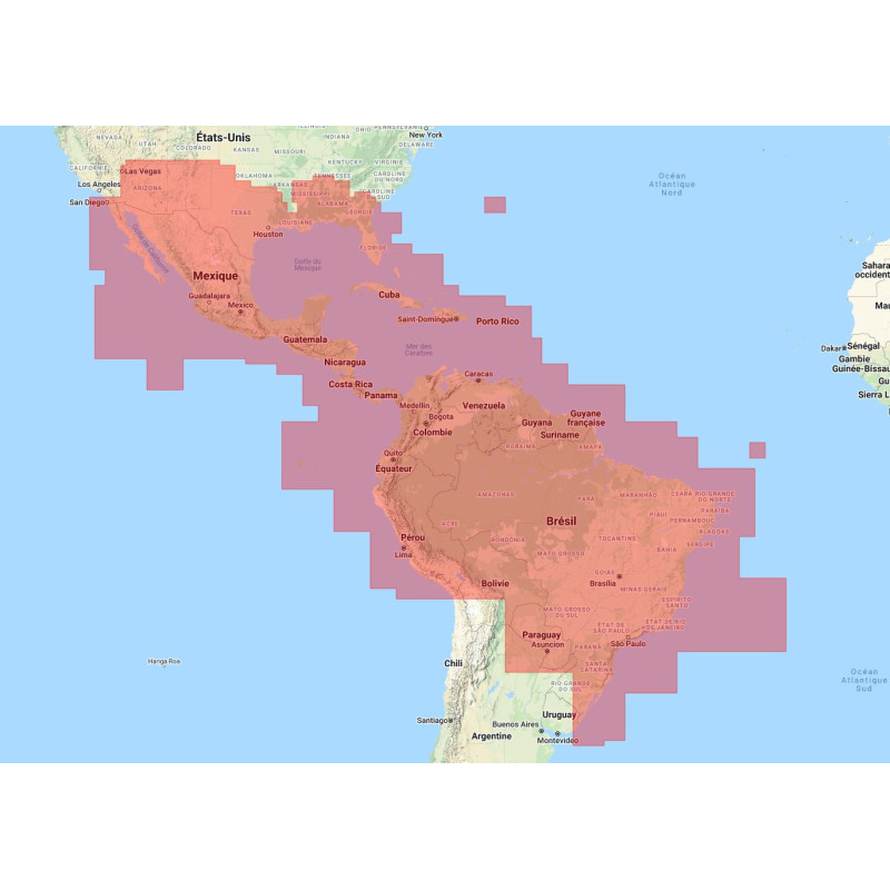
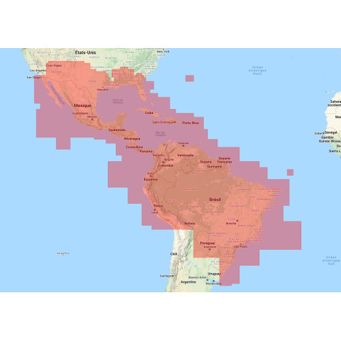
Nautical chart Navionics - Navionics+ Large NASA004L - Mexico, Caribbean to Brazil
search
  • googlemap
  • Nautical chart Navionics - Navionics+ Large NASA004L - Mexico, Caribbean to Brazil
  • Nautical chart Navionics - Navionics+ Large NASA004L - Mexico, Caribbean to Brazil
  • Nautical chart Navionics - Navionics+ Large NASA004L - Mexico, Caribbean to Brazil

Nautical chart Navionics - Navionics+ Large NASA004L - Mexico, Caribbean to Brazil

€193.88
€184.18
-5%
Navionics
on SD / micro SD card
Custom-programmed chart
Estimated preparation time: 0 to 2 days
Navionics is the world leader in digital navigation charts.
nav-cn-NASA004L
1 Item

Data sheet

Size
SD card / micro SD card with SD adapter
Year
chart printed to order incorporating the latest corrections
Author
Navionics
Plotter brand or software brand
Actia
Alphatron marine
B&G
DeLorme
Faria
Furuno
Garmin
GeoNav
Humminbird
Jmc
Lorenz
Lowrance
Magellan
MarCum
Marine Pan Systems
Medallion
Naviop
Onwa
Polar
Raymarine
Samyung ENC
Seiwa
Si-Tex
Simrad
Vetus powered by LxNav
lxnav Marine
Plotter model
7M Gold
587
587CI HD
595c
597
597CI HD
597CI HD DI
598CI HD SI
688CI HD
688CI HD DI
688CI HD DI KVD NAV
688CI HD XD
698CI HD SI
698CI HD SI KVD
737
755
757
767
785
786
787
788ci HD
788ci HD Combo CHO
788ci HD DI
797
798
798ci HD SI
858c HD
858c HD DI
859CI HD
859CI HD DI
859CI HD XD
893
898c HD SI
899CI HD SI
899CI HD SI NAV
899CXI HD SI
917
937
947
955
957
958
958c HD
958c HD DI
959CI HD
959CI HD DI
967
987
997
998
998c HD SI
998c SI
999CI HD SI
999CI HD SI KVD
1155
1157
1158c
1158c DI
1159CI HD
1159CI HD DI
1159CI HD XD
1197
1198c SI
1199CI HD SI
1199CI HD SI KVD
AIS 50N
AIS700
APEX series
Actia
Atom 9
Atom 9+
Atom 12
Atom 12+
Axiom+ 7
Axiom+ 7 RVX
Axiom+ 7 RVX RV100
Axiom+ 9
Axiom+ 9 AIS700
Axiom+ 9 RVX
Axiom+ 9 RVX AIS700
Axiom+ 9 RVX RV100
Axiom+ 9 RVX RV100 AIS700
Axiom+ 12
Axiom+ 12 RVX
Axiom+ 12 RVX AIS700
Axiom+ 12 RVX RV100
Axiom+ 12 RVX RV100 AIS700
Axiom 7
Axiom 7 CPT103
Axiom 9
Axiom 9 CPT100
Axiom 9 Pro RVK
Axiom 9 Pro RVK inkl AIS700
Axiom 9 Pro RVX inkl heckgeber CPT-103
Axiom 9 Pro S
Axiom 9 Pro S inkl AIS700
Axiom 9 RVK RV100
Axiom 9 RVX
Axiom 12
Axiom 12 Pro RVX
Axiom 12 Pro S
Axiom 12 Pro S inkl AIS700
Axiom 12 Pro inkl AIS700
Axiom 12 RVX
Axiom 12 RVX RV100
Axiom 16 Pro RVX
Axiom 16 Pro RVX AIS700
Axiom 16 Pro S
Axiom 16 Pro S inkl AIS700
Axiom 16 XL
Axiom 19 XL
Axiom 22 XL
Axiom 24 XL
Axium 7 CPT-S
Axium 7 DV
C1
C 90W
C 120W
C 140W
CPT DVS geber
Cruise 5
Cruise 7
Cruise 9
DigiNav
Digital Yacht SmarterTrack
Dragonfly 4 Pro
Dragonfly 5 Pro
Dragonfly 7 Pro
Dragonfly Series
E 120W
E 140W
E500
E700
E900
Earthmate PN-30
Earthmate PN-40
Earthmate PN-60
Element 7 HV
Element 7 HV CPT100 Geber
Element 7 HV HV100 Geber
Element 7S
Element 9 HV
Element 9 HV CPT100 Geber
Element 9 HV HV100 Geber
Element 9S
Element 12 HV
Element 12 HV HV100 Geber
Element 12S
Element S Series
Elite 7 Broadband
Elite 7 HDI
Elite 7/9 CHIRP
Elite FS series
Elite Ti2 series
Elite Ti series
Explorer 23
FF-901
G10
G12
G120
G150
G170
G190
GIS10
GIS12
GO 5
GO 7 XSE
GO7 XSR
GO7 XSR AI Geber
GO7 XSR HDI Geber
GO9 XSE
GO9 XSE AI Geber
GO9 XSE Forward Scan Geber
GO9 XSE HDI Geber
GO 12 XSE
GO XSR
GP 7000/N
GPS Chart CPF390i
GPSMAP 723
GPSMAP 723xsv
GPSMAP 923
GPSMAP 923xsv
GPSMAP 1022
GPSMAP 1022xsv
GPSMAP 1040xs
GPSMAP 1042xsv
GPSMAP 1222
GPSMAP 1222 PLUS inkl. CAMINO 108S
GPSMAP 1222 PLUS inkl. GPSMAP 79s
GPSMAP 1222 PLUS inkl. Geber PANOPTIX PS51-TH
GPSMAP 1222 PLUS inkl. PANOPTIX LiveScope
GPSMAP 1222 PLUS inkl. Quatix 6
GPSMAP 1222 PLUS inkl. inReach mini 2 orange
GPSMAP 1222 Plus
GPSMAP 1222 Plus GMR 18HD+
GPSMAP 1222 Plus GMR Fantom 18
GPSMAP 1222xsv
GPSMAP 1222xsv Plus
GPSMAP 1223
GPSMAP 1223xsv
GPSMAP 1242xsv
GPSMAP 8410
GPSMAP 8410xsv
GPSMAP 8412
GPSMAP 8412xsv
GPSMAP 8416
GPSMAP 8416xsv
Genius 7
Genius 7 Glass
Genius 10
Genius 13
Genius 15
Genius 15 Glass
HDS 7 Live
HDS 7 Live inkl Al Geber
HDS 9 Live
HDS 9 Live inkl Al Geber
HDS 12 Live
HDS 12 Live inkl Al Geber
HDS 16 Live
HDS 16 Live inkl Al Geber
HDS Carbon series
HDS Gen1 series
HDS Gen2 Touch series
HDS Gen2 series
HDS Gen3 Carbon series
HDS Gen3 series
HELIX 5 DI GPS
HELIX 5 GPS
HELIX 5 SI GPS
HELIX 5 SI GPS KVD
HELIX 5 SONAR GPS
HELIX 5 XD GPS
HELIX 7 DI GPS
HELIX 7 GPS
HELIX 7 SI GPS
HELIX 7 SI GPS KVD
HELIX 7 SONAR GPS
HELIX 7 X GPS
HELIX 10 DI GPS
HELIX 10 SI GPS
HELIX 10 SI GPS KVD
HELIX 10 SONAR GPS
Hook 2 Combo series
Hook 2 series
Hook Reveal 5 ink 20/200 khz Geber
Hook Reveal 5 ink Splitshot
Hook Reveal 7 ink 50/200 khz Geber
Hook Reveal 7 ink Splitshot
Hook Reveal 7 ink Tripleshot
Hook Reveal 9 ink 50/200 khz Geber
Hook Reveal 9 ink Tripleshot
Hook series
IDS
ION 10
ION 12
KCombo-7
KCombo-7A
KM-8
KM-8A
KM-8C
KM-8X
KM-12
KM-12A
KM-12C
KM-12X
KP-38
KP-38A
KP-38S
KP-39
KP-39A
KP-708
KP-708A
KP-1299
KP-1299A
KP-1299C
KP-1299X
MX-7GPS
MX-7GPSLI
Maestro Mach-7
Magnum Pro HD
Matrix 87
Matrix 87c
Matrix 97
Medallion
N9
N9-Fish
N12
N12-Fish
NAVIS 120
NAVIS 430
NAVIS 700
NAVIS 800
NAVIS 2500
NAVIS 2600
NAVIS 3000
NAVIS 3100
NAVIS 3700
NAVIS 3800
NAVIS 5100
NAVIS N/NF 100
NAVIS N/NF 120
NAVIS N/NF 560
NAVIS N/NF 700
NAVIS N/NF 800
NP-90 MAX
NP-120 MAX
NSE 8
NSE 12
NSO15 15
NSO evo2 Series
NSO evo3
NSO evo3S
NSS7 evo3
NSS9 evo3
NSS9 evo3S
NSS12 evo3
NSS12 evo3S
NSS16 evo3S
NSS Series
NSS evo2 Series
NSS evo3
NSS evo3S
NavPro
NavPro 900
NavPro 900F
NavPro 1200
NavPro 1200F
Navigation Planner
Navnet VX2 1720C
Navnet VX2 1724C
Navnet VX2 1734C
Navnet VX2 1824C
Navnet VX2 1824CBB
Navnet VX2 1834C
Navnet VX2 1834CBB
Navnet VX2 1920C
Navnet VX2 1920C/CBB
Navnet VX2 1934C
Navnet VX2 1934CBB
Navnet VX2 1944
Navnet VX2 1944CBB
Navnet VX2 1954C
Navnet VX2 1954CBB
Navnet VX2 1964C
Navnet VX2 1964CBB
Navnet VX2 GP1720C
ONIX 8
ONIX 8 SI
ONIX 10
ONIX 10 SI
PC Plotter
Plotter Controller PCC-202
Plotter Controller PCP-209
Plotter Controller PCP-222
SAS-300
SAS-560 5
SAS-750
SAS-760
SAS-760 7
SAS-880
SAS-SVS1010
SOLIX G2 series
SOLIX G3 series
SOLIX series
SVS-460
SVS-460 4
SVS-560
SWx 90w
SWx 900cw
SWx 1200cw
SWx 1200w
ScanNav
Super Pilot Max III
TIKI Navigator
TMQ C-Plot Nav+
TP-9
V-90P MAX
V-120P MAX
Vulcan 5
Vulcan 7
Vulcan 7FS
Vulcan 7R
Vulcan 9
Vulcan 9FS
Vulcan 12
WASSP CDX
Zeus
Zeus 2
Zeus 2 Glass Helm
Zeus 2 Touch
Zeus 3
Zeus 3 Glass Helm
Zeus 3S 9
Zeus 3S 12
Zeus 3S 16
Zeus 3S Glass Helm
a-MFD series
c-MFD series
e-MFD Series
eS MFD Series
eXplorist 510
eXplorist 610
eXplorist 710
echoMAP UHD2 52cv
echoMAP UHD2 52cv / GT20-TM
echoMAP UHD2 72cv
echoMAP UHD2 72cv / GT20-TM
echoMAP UHD 72sv
echoMAP UHD 92sv
echoMAP Ultra 102sv
echoMAP Ultra 122sv
Vector chart
Navionics+ Large
Picto
on SD / micro SD card
Digital chart type
Format vectoriel
Digital media
SD card / micro SD card with SD adapter
Support
digital version
Digital char version
new chart
Plotter or routing software
Plotter

Specific References

UPC
400000054292
EAN13
4000000108658
New
Custom-programmed chart
Description détaillée

This Navionics Navionics+ Large digital nautical chart covers : Mexico, Caribbean to Brazil

We strive to market only the latest versions.

Navionics charts are available only on SD / MicroSD cards with an adapter; Compact Flash format is no longer offered.

Navionics is the world?s number one provider of digital navigation charts. These charts are compatible with most marine chart readers / plotters and GPS / fishfinder combo devices. The Navionics catalog offers one of the most detailed databases ever created for seas and lakes. It includes all essential cartographic details for boating, sailing, and fishing: harbor plans, safe depth contours, maritime services, tides and currents, and navigation aids.

Navionics digital charts have been continuously enhanced for over 30 years thanks to high-quality data from public and private sources, as well as Navionics? own research, Notices to Mariners, and user reports.

The Navionics charts we sell are designed for chartplotters. They are not compatible with smartphones or tablets.

Navionics Marine Charts: Navigate with Precision, Reliability, and Peace of Mind

Navionics marine charts now cover all coastal and offshore navigation areas worldwide, with a level of detail highly valued by recreational boaters. Whether you are sailing in the Mediterranean, along the Atlantic coast, in the English Channel, in the Pacific, or on inland waters, these charts are designed to support all types of navigation?from day trips to extended cruises.

Choosing the right marine chart for your navigation area is essential for ensuring safety at sea. Accurate mapping helps anticipate hazards, optimize your route, and comply with maritime regulations. Navionics charts follow this approach by offering clear readability, up-to-date data, and broad compatibility with modern equipment.

What is a Navionics marine chart used for?

A Navionics marine chart is more than just a representation of a coastline?it is a true decision-support tool for navigation.

It allows you to:

  • Plan a route by identifying shallow areas, channels, and recommended routes
  • Navigate safely near the coast with detailed buoyage
  • Locate ports, anchorages, shelters, and service areas
  • Anticipate hazards such as rocks, wrecks, restricted or regulated zones

In real-life situations, these charts are used for:

  • Coastal navigation with sometimes complex harbor entries
  • Crossings requiring quick reading of depths and alignments
  • Fishing sessions requiring a good understanding of bathymetry
  • Cruises with planned stopovers
  • Around-the-world voyages

Compared to generic charts or mobile apps alone, Navionics charts provide structured information designed for navigators, with visual prioritization that supports quick decision-making.

Who are these charts recommended for?

Navionics charts are suitable for a wide range of users, which explains their popularity in recreational boating.

They are particularly suitable for:

  • Beginner navigators, thanks to their clarity and intuitive design
  • Experienced boaters looking for precision and rich data
  • Professionals or semi-professionals, as a complement to certified systems

They are adapted for:

  • Day and night navigation
  • Occasional use (weekend outings) or regular use (long cruises)

They integrate seamlessly with:

  • GPS chartplotters
  • Onboard navigation systems
  • Marine charting software

The goal is clear: to allow every navigator to visualize real-world use, regardless of their level or vessel.

Chart reading and understanding

One of the strengths of Navionics charts lies in their ease of use, even for less experienced users.

Chart scale determines the level of detail:

  • Large scale: ideal for harbor approaches and complex areas
  • Small scale: suitable for offshore navigation

Key visible information includes:

  • Depths (bathymetry) with contour lines
  • Maritime buoyage (buoys, lights, cardinal marks)
  • Hazards (rocks, wrecks, shoals)
  • Infrastructure (ports, marinas, anchorages)

To use a Navionics chart properly, a navigator must:

  • Understand marine symbols and conventions
  • Know how to interpret depths in relation to tides
  • Adapt navigation to real conditions (wind, current, visibility)

Good chart-reading skills remain fundamental, even in the digital age.

Reliability, updates, and safety

Navionics charts rely on a regular update system, which is essential for ensuring safe navigation.

Data is enhanced using:

  • Official hydrographic sources
  • Contributions from navigators (soundings, surveys)
  • Frequent updates via digital services

Why is this essential?

The marine environment constantly changes: shifting sandbanks, updated buoyage, new harbor developments. An up-to-date chart helps avoid potentially critical errors.

Navionics charts are compatible with modern reference systems such as WGS 84, ensuring consistency with current GPS systems.

Best practices:

Regularly check for available updates
Never rely on a single source of information
Cross-check data with other navigation tools

This is a cornerstone of safety at sea and the reliability of your equipment.

Paper charts vs digital charts: when and why choose this format

Although Navionics is primarily known for digital charts, the choice of medium remains important.

Advantages of digital (Navionics):

  • Easy and fast updates
  • Dynamic zoom and customization
  • Integration with onboard instruments

Why keep a paper chart?

  • Energy independence (no battery required)
  • Global overview of the area
  • Backup solution in case of electronic failure

In practice, most experienced navigators use both:

  • Digital for precision and comfort
  • Paper for safety and planning

Complementarity remains the best approach.

Why choose this marine chart (publisher + Nautic Way selection)

Navionics has established itself as a major player in nautical cartography thanks to its innovation and rich data.

What sets this publisher apart:

  • Worldwide coverage
  • Continuous updates
  • User-focused interface

The selection offered by Nautic Way goes beyond a simple catalog:

  • Each chart is chosen for its real relevance in navigation
  • The editions offered are up-to-date and reliable
  • Professional expertise helps guide users toward the right product

Nautic Way acts as a quality filter in a complex market.

Expert FAQ

Which marine chart should I choose for this area?
It depends on your exact location and type of navigation. A chart covering your area broadly with good coastal detail is recommended.

Is this chart sufficient on its own?
No. Even a very comprehensive chart should always be used alongside other tools (GPS, onboard instruments, visual observation).

How often should it be replaced?
For a Navionics digital chart, regular updates are sufficient. It is recommended to check availability before each season.

Can it be used with a GPS?
Yes, Navionics charts are designed to be compatible with most modern GPS chartplotters.

What is the difference with an SHOM chart?
SHOM charts are official references, often used for regulatory navigation. Navionics offers a more interactive, user-oriented approach, particularly suited to recreational boating.

Is it suitable for offshore navigation?
Yes, provided you choose a chart covering the relevant area and integrate it into an overall navigation strategy.

Are Navionics charts compatible with all readers / plotters?
No. Please use the filters on our Google Map:
1 - Choose chartplotter or routing software
2 - Choose chartplotter brand or routing software
3 - Choose chartplotter model
4 - Choose hydrographic service or publisher
5 - Choose chart status
6 - Choose compatible charts
If in doubt, please contact us.

Conclusion

Navionics marine charts are not just mapping tools?they are essential instruments for safe navigation, understanding your environment, and making the right decisions at sea.

When used thoughtfully alongside other instruments and solid navigation knowledge, they become a valuable ally for all navigators.

All Navionics digital marine charts are produced on demand and include the latest updates. Due to obsolescence, they cannot be returned or exchanged.

Compatibility verification procedure for Navionics charts

First check: Navionics charts are only compatible with certain chartplotters. WE STRONGLY RECOMMEND USING THE FILTERS ON OUR GOOGLE MAP TO VERIFY COMPATIBILITY WITH YOUR EQUIPMENT: BRAND / MODEL / AREA.

Second check: When placing your order, please specify in the designated text field (next to the shipping method selection) the brand and model of the chartplotter or software intended to use this digital chart. We will perform an additional compatibility check.

Loading...