
The Shipping Guides - ATL0075 - The Shipping World's Map
search
  • googlemap
  • The Shipping Guides - ATL0075 - The Shipping World's Map

The Shipping Guides - The Shipping World's Map

€81.80
Tax included
In English language
Estimated preparation time: 5 to 14 days

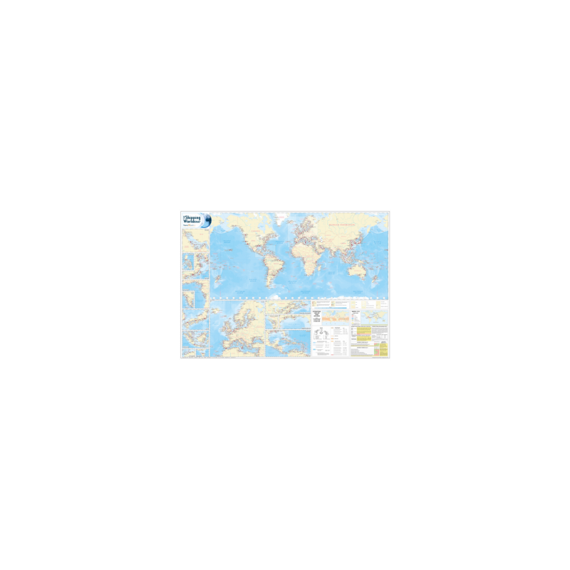
Navigate global trade with this laminated A0-sized world shipping map, featuring over 2,000 ports, cargo types, and key maritime details. Perfect for offices or navigation hubs.

ATL0075

Data sheet

Who is the publisher or the author?
The Shipping Guides
Picto
In English language

Specific References

UPC
400000215808
EAN13
4000000000280
New
Description détaillée

The Shipping World's Map

Reference work in English
Paper version

An Essential Tool for Global Maritime Navigation

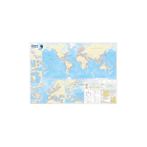
The Shipping World's Map is the definitive wall chart for maritime professionals, offering an unparalleled overview of the world’s ports and terminals. Designed for clarity and precision, this large-format map provides critical data for navigation, logistics, and strategic planning in the shipping industry. With over 2,000 ports and terminals meticulously plotted, it serves as a vital resource for ship operators, port authorities, and maritime consultants.

Comprehensive Port Coverage and Detailed Insights

This map delivers an exhaustive representation of global maritime infrastructure, including major and minor ports across every continent. Each edition introduces new entries—503 in the 9th edition alone—ensuring up-to-date coverage of emerging trade hubs. Symbols indicate port size, cargo types handled, and the availability of drydock facilities for large vessels, allowing users to quickly assess capabilities and constraints. Enlarged insets for congested regions, such as Europe, the Mediterranean, and East Asia, provide enhanced visibility for high-traffic areas.

Regulatory Compliance and Operational Efficiency

Stay compliant with international maritime regulations thanks to integrated MARPOL 73/78 load line maps, including the latest amendments and Emission Control Areas (ECAs) for NOx Tier III standards. The map also features UTC time zone clocks and key day docks, streamlining operational planning. Whether used in an office, boardroom, or navigation bridge, this tool ensures seamless coordination across global shipping routes.

Built for Durability and Professional Use

Printed on high-quality, laminated A0 paper (1189 x 841 mm), the map is designed to withstand frequent handling in demanding environments. Its robust finish resists wear and tear, making it ideal for long-term use in maritime settings. The 9th edition, last updated in March 2013, remains a trusted reference for professionals seeking accuracy and reliability in maritime navigation.

Navigate the Global Shipping Network with Precision
The Shipping World's Map is the ultimate visual reference for maritime professionals, combining unmatched detail with practical functionality. This large-format wall chart transforms complex shipping data into an intuitive, easy-to-read layout, making it indispensable for decision-makers in the industry. Whether you're planning routes, analyzing port capacities, or ensuring regulatory compliance, this map provides the insights you need at a glance.

Unrivaled Port and Terminal Data
With over 2,000 ports and terminals mapped worldwide, this chart offers the most comprehensive coverage available. Each port is represented with symbols indicating its relative size, cargo types, and drydock capabilities, allowing users to quickly evaluate infrastructure. The 9th edition introduces 503 new entries, reflecting the latest developments in global trade. Enlarged insets for high-traffic regions ensure clarity in congested areas, while MARPOL 73/78 load line maps keep you aligned with international regulations.

Designed for Professional Environments
Engineered for durability, the map is printed on laminated A0 paper (1189 x 841 mm), ensuring it stands up to daily use in offices, boardrooms, or navigation bridges. Its robust construction resists damage, while the clear, high-contrast design guarantees readability even from a distance. Updated as of March 2013, this edition remains a trusted resource for maritime professionals who demand accuracy and reliability.

This large-format wall chart measures 1189 x 841 mm (A0 size) and weighs 1.5 kg, making it ideal for professional display. Laminated for durability, it covers over 2,000 ports and terminals worldwide, with 503 new entries added in the 9th edition. The map includes detailed symbols for port size, cargo types, and drydock facilities, along with enlarged insets for congested regions and MARPOL 73/78 load line compliance data.

A leader in maritime reference materials, this publisher specializes in creating tools that enhance operational efficiency and compliance for shipping professionals. Their products are trusted by industry experts for their accuracy, durability, and practical design, making them a go-to resource for global maritime navigation.

  • This map offers unparalleled coverage of global ports and terminals, with detailed symbols for quick assessment of infrastructure. Its laminated A0 format ensures durability, while enlarged insets and regulatory compliance data make it a versatile tool for strategic planning. Ideal for offices, boardrooms, or navigation bridges, it simplifies complex maritime data into an intuitive, easy-to-use format.
What is the size of the laminated map?

The map is in A0 size, measuring 1189 x 841 millimeters and comes laminated for durability.

How many ports and terminals are included in the latest edition?

The latest edition includes over 2,000 ports and terminals worldwide, with 503 new entries added.

Are there any specific symbols used to indicate port details?

Yes, the map uses symbols to indicate the relative size of ports, types of cargo handled, and availability of drydock facilities for large vessels.

Does the map include information on international load lines?

Yes, it features detailed inset maps showing international load lines and MARPOL 73/78 regulations, including ECAs for the Baltic and North Sea.

What is the weight of the map?

The map weighs approximately 1.5 kilograms.

Are there enlarged views of specific regions?

Yes, the map includes enlarged views of congested areas such as Europe, the Mediterranean, Australia, and Japan for better clarity.

When was the last update for this edition?

The last update for this edition was in March 2013.

Loading...