




Navicarte nautical chart, coasts of France and Spain.
Data sheet
Specific References
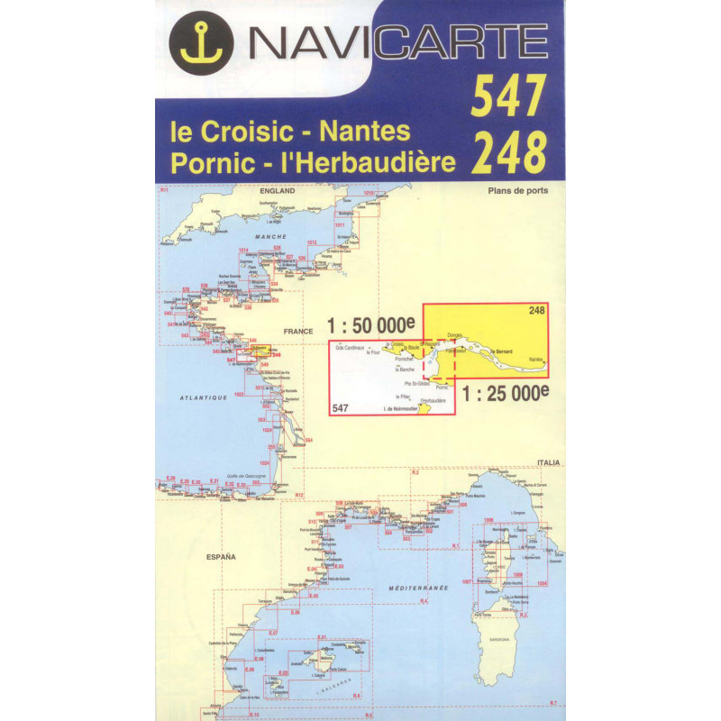
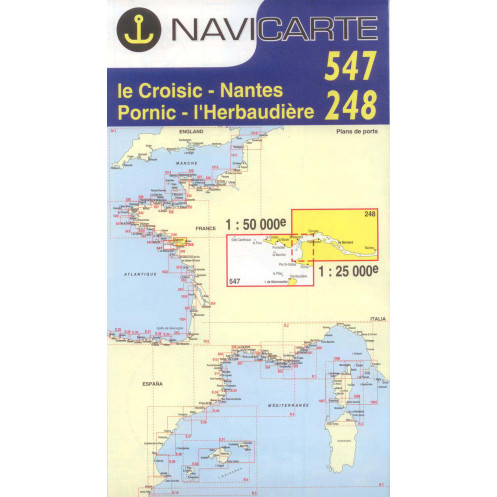
The Navicarte 547 + 248 nautical chart covers an important section of the French Atlantic coast around Le Croisic, the Loire estuary and Pornic. It combines two chart references, with scales of 1:50,000 and 1:25,000, providing both a broader view suitable for coastal navigation and a more detailed representation of specific areas. This folded paper chart is primarily intended for sailors planning coastal passages between southern Brittany, Loire-Atlantique and the northern Vendée coast.
The Navicarte 547 + 248 is particularly suitable for planning coastal navigation around Le Croisic, Nantes and Pornic. This area has a varied maritime environment, including open coastal waters, port approaches and the specific navigational conditions associated with the Loire estuary.
The use of two scales is an important feature of this chart. The 1:50,000 scale provides a sufficiently broad view for planning a coastal route and understanding the overall layout of the area. The 1:25,000 scale provides greater detail when the navigator needs to work on a more restricted section of the chart.
This combination makes the chart useful for preparing a coastal cruise, a cabotage passage or a recreational boating itinerary along this section of the French Atlantic coast.
The Navicarte 547 + 248 is classified as a nautical chart intended for recreational boating and coastal navigation. It can be used by sailing yacht owners, motorboat crews, coastal cruisers and sailors preparing a cruise along the Atlantic coast.
The paper chart can be used to plan a route before departure, compare different navigation options and maintain an overall view of the area. It is also useful when discussing the planned itinerary with the crew or working at the chart table.
For sailors looking for a nautical chart covering Le Croisic and Pornic, or a chart for the Le Croisic and Nantes area, the Navicarte 547 + 248 provides dedicated coverage of this section of the French Atlantic coast.
Scale is an essential factor when choosing a nautical chart. A 1:50,000 chart represents a relatively large geographical area while retaining a level of detail suitable for coastal navigation.
The 1:25,000 scale provides a more detailed representation. It is particularly useful when the navigator needs to examine a smaller navigation area, prepare an approach or study local conditions more closely.
The Navicarte 547 + 248 is therefore particularly useful for sailors who want several levels of cartographic detail within the same chart set.
The paper nautical chart can be used to prepare different types of navigation:
coastal navigation around Le Croisic;
a coastal cruise between Le Croisic and Pornic;
navigation in the Loire area;
route planning between ports along the Atlantic coast;
chart-table route planning;
preparation alongside GPS and electronic navigation systems;
general assessment of the area before departure.
The chart can also be used to plot a route, record navigation information and work independently of an electronic display.
A paper chart does not replace electronic navigation equipment; it complements it. A GPS or chartplotter provides the vessel's position, while the paper chart provides an overall representation of the navigation area.
This combination is particularly useful when preparing a coastal passage. The navigator can first study the route on paper, identify areas requiring particular attention and then use the GPS or chartplotter to monitor the vessel's position while underway.
In the event of an electronic failure, power supply problem or difficulty using an electronic display, the paper chart also remains available as an independent navigation reference.
Publisher: Navicarte
Chart references: 547 + 248
Type: nautical navigation chart
Area: Atlantic Ocean
Coverage: Le Croisic, Nantes, Pornic
Navigation: recreational boating, coastal navigation
Scales: 1:50,000 and 1:25,000
Support: paper
Format: folded chart
Unfolded format: A0, 118.9 × 84.1 cm
Folded format: approximately 166 × 315 mm
Language indicated for the range: French
A nautical chart needs to remain readable and easy to handle during the different stages of voyage preparation. The folded format makes storage on board easier, while the unfolded format provides a much larger representation of the navigation area.
Navicarte charts use a graphic presentation designed to facilitate the reading of information required by recreational sailors. Charted depths, buoyage, hazards, ports and other nautical information must always be interpreted in conjunction with the actual navigation situation and the applicable official nautical information.
The Navicarte 547 + 248 is suitable for both sailing yachts and motorboats engaged in coastal navigation. It can be used for a short coastal trip as well as for planning a longer cruise requiring several consecutive charts.
It is particularly useful when the planned route is around Le Croisic, Nantes or Pornic and the navigator wants a paper chart covering this section of the Atlantic coast.
What area does the Navicarte 547 + 248 cover?
It covers the maritime area around Le Croisic, Nantes and Pornic on the French Atlantic coast.
What are the scales of the Navicarte 547 + 248?
It combines two scales: 1:50,000 and 1:25,000, providing complementary levels of cartographic detail.
Is the Navicarte 547 + 248 suitable for recreational boating?
Yes. It is intended for recreational boating and coastal navigation.
Is it a paper or electronic chart?
It is a folded paper nautical chart.
What is the unfolded size?
The chart is A0 size when unfolded, approximately 118.9 × 84.1 cm.
What is the folded size?
The folded format is approximately 166 × 315 mm, making it easier to store on board.
Can this chart be used with GPS?
Yes. The paper chart is complementary to GPS, chartplotters and other electronic navigation systems.
Is it suitable for navigation between Le Croisic and Pornic?
Yes. The geographical coverage is specifically intended for this section of the French Atlantic coast.
Why are two chart references, 547 and 248, combined?
The two references correspond to the combined cartographic coverage offered by this chart, with two complementary scales.
Does this chart replace official nautical information?
No. Before navigation, the navigator should check the available edition, current nautical information and any changes affecting the area being navigated.
You might also like