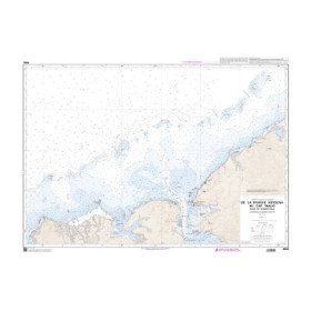

Navicarte nautical chart, coasts of France and Spain.
Data sheet
Specific References
The Navicarte 555 nautical chart covers the Cap Breton and Lekeito area on the Atlantic coast, close to the French-Spanish border. With a scale of 1:50,000, it is intended for coastal navigation and recreational boating.
This folded paper chart allows sailors to plan a route along this section of the Atlantic coast, study the general configuration of the area and keep an independent paper navigation reference on board alongside electronic systems.
The Navicarte 555 is particularly relevant for sailors looking for a nautical chart covering Cap Breton and Lekeito, especially when planning coastal navigation or a route connecting the French and Spanish Atlantic coasts.
The Navicarte 555 covers an area extending from the French Atlantic coast towards the northern Spanish coastline. The chart title clearly identifies its two main geographical references: Cap Breton and Lekeito.
This coverage makes the chart suitable for sailors planning coastal navigation in this part of the Bay of Biscay.
The 1:50,000 scale provides a balance between an overall view and a useful level of cartographic detail. It allows the navigator to plan a coastal route while retaining a sufficiently broad representation of the area.
The Navicarte 555 is classified as a navigation chart for coastal use. It is therefore suitable for recreational sailors using either sailing yachts or motorboats.
It can accompany a coastal trip, a recreational cruise or a longer passage requiring several consecutive charts.
For sailors looking for a nautical chart of Cap Breton and Lekeito, reference 555 provides a document specifically focused on this Atlantic coastal area.
The 1:50,000 scale represents a significant geographical area while retaining an appropriate amount of information for coastal navigation planning.
One centimetre on the chart represents 500 metres on the ground. This scale is therefore sufficiently broad for route planning while allowing the main characteristics of the coastline to be studied.
The navigator should nevertheless always select the chart scale according to the situation. Any approach requiring greater precision should be carried out using charting at an appropriate larger scale.
The Navicarte 555 is particularly useful for sailors undertaking passages along the Atlantic coast between France and northern Spain.
A paper chart allows the navigator to visualise the continuity of the route and plan the different stages of a coastal passage. It can be combined with additional charts when the planned route extends beyond the area covered.
For international navigation, the navigator must naturally take into account the relevant nautical and regulatory information for the waters being crossed.
Reading a nautical chart requires an understanding of its symbols and conventions, including scale, soundings, buoyage, lights, hazards, ports, coastal landmarks and other charted information.
Navicarte charts are designed to facilitate this interpretation through a graphic presentation suitable for recreational sailors. The navigator must nevertheless understand the conventions used and interpret the information according to the actual navigation situation.
The chart is not simply a geographical representation. It is a tool for developing a navigation strategy, anticipating the different stages of a passage and checking the consistency of the planned route.
The Navicarte 555 can be used alongside a GPS or chartplotter.
Electronic equipment provides a dynamic position and allows the navigator to monitor the vessel's progress. The paper chart provides a broad overview and allows route planning independently of the electronic display.
This combination is particularly valuable during coastal navigation across a relatively extensive area. It also provides an independent reference in the event of an electronic or electrical problem.
Publisher: Navicarte
Chart reference: 555
Scale: 1:50,000
Type: nautical navigation chart
Use: recreational boating
Navigation: coastal
Geographical area: Atlantic Ocean
Coverage: Cap Breton, Lekeito
Support: paper
Format: folded chart
Unfolded format: A0, 118.9 × 84.1 cm
Language indicated on the product page: French
The chart is supplied folded to make storage easier. It can be kept in a chart table or another suitable navigation storage area.
When unfolded, it provides an A0 surface measuring 118.9 × 84.1 cm. This allows a significant part of the area to be viewed and makes route planning possible with several crew members.
The paper format also allows the chart to be consulted without electrical power, which is an important advantage when maintaining redundancy in navigation equipment.
The Navicarte 555 forms part of a series of charts covering the Atlantic coast. It is particularly useful when the planned route involves the Cap Breton area and continues towards Lekeito.
For a longer cruise in the Bay of Biscay, it can be combined with other Navicarte charts covering the areas before or after this sector.
The choice of additional charts should always be based on the planned route and the scale required for each stage.
The product page indicates 2019 for this chart. This is the year displayed on the product page.
It should not be interpreted as a guarantee that this is the most recent edition available. Before navigation, the navigator should check the edition being used and consult relevant nautical information that may have changed.
This precaution is particularly important for coastal navigation, where buoyage, hydrographic conditions and certain regulations may be modified.
What area does the Navicarte 555 cover?
It covers the Cap Breton and Lekeito area on the Atlantic coast.
What is the scale of the Navicarte 555?
The chart has a scale of 1:50,000.
Is the Navicarte 555 suitable for coastal navigation?
Yes. It is classified as a chart intended for coastal navigation.
Is this chart suitable for recreational boating?
Yes. It is intended for recreational sailors, both under sail and by motor.
Is it a paper chart?
Yes. It is a folded paper nautical chart.
What is the size of the Navicarte 555?
Its unfolded format is A0, approximately 118.9 × 84.1 cm.
What year is indicated for chart 555?
The product page indicates 2019. The available edition should be checked before using the chart for navigation.
Can the Navicarte 555 be used with GPS or a chartplotter?
Yes. The paper chart complements electronic navigation systems.
Is it suitable for navigation between France and Spain?
Its coverage includes Cap Breton and Lekeito, making it relevant to coastal navigation in this part of the Atlantic, particularly for routes connecting French and Spanish coastal areas.
Is the Navicarte 555 sufficient for a long passage across the Bay of Biscay?
It covers a specific area and should not be considered sufficient for a route extending beyond that area. Additional charts should be selected according to the planned route and the required scales.
Why keep this paper chart alongside electronic charting?
It provides an overall view independent of electrical power and serves as a complementary reference for both route planning and navigation monitoring.
You might also like