
 Click here to open our interactive map and select your charts


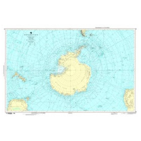
NGA Antarctica Nautical Chart
The Antarctic Ocean, also known as the Southern Ocean, surrounds the Antarctic continent and is one of the most isolated and challenging maritime regions in the world. Navigation in this area includes the Antarctic Peninsula, the Weddell Sea, the Ross Sea, the South Orkney Islands and areas close to scientific research stations.
An NGA nautical chart for Antarctica is documentation produced by the NGA – National Geospatial-Intelligence Agency, the U.S. organisation responsible for numerous geospatial and nautical products. Its Antarctic coverage includes the DNCX029 – Antarctica region, organised into general and coastal sectors.
An NGA nautical chart may be used to plan ocean or offshore navigation, coastal approaches, polar expeditions or scientific voyages. The appropriate product depends on the area, route and level of detail required.
Nautic Way specialises in nautical charts and maritime documentation and offers charts and publications for international, offshore and polar navigation.
What is an NGA nautical chart of Antarctica used for?
A nautical chart provides a geographical reference for planning and analysing a route.
Depending on the product and area, it may show:
-
coastlines, islands and archipelagos;
-
soundings and depths;
-
shoals and hazards;
-
charted rocks and wrecks;
-
channels and passages;
-
infrastructure and installations;
-
aids to navigation where represented;
-
various geographical and maritime features useful for route planning.
For navigation towards Antarctica, charting should be considered at several levels.
An ocean chart provides an overall view of the region and can be used to plan an ocean crossing.
An offshore chart is suitable for monitoring a route well offshore.
A coastal chart provides greater detail as the vessel approaches the continent or an archipelago.
An approach chart provides even more detailed information for a specific coastal area.
The choice of an NGA Antarctica nautical chart should therefore be based on the planned route rather than simply on the name of the region.
What type of navigator uses these charts?
NGA charts of Antarctica may be of interest to a wide range of users.
Long-distance cruising and ocean navigation
Cruisers undertaking long-distance voyages or expeditions can use charting to plan the different stages of their route.
Offshore sailors and circumnavigators
A circumnavigation may require charts and publications from several cartographic producers. NGA documentation can therefore complement charts used for other oceans and regions along the voyage.
Scientific and polar expeditions
Antarctica is a major destination for scientific, oceanographic and expedition vessels. Nautical charting is therefore an important part of documentary and voyage preparation.
Professional mariners
Shipowners, crews and maritime professionals may use NGA charts to analyse international routes and plan voyages.
However, a chart should not be considered sufficient on its own to meet any documentary requirements that may apply to a professional vessel.
Sailing schools and training centres
Nautical charts are also valuable educational tools for learning about position fixing, chart scales, cartographic symbols and route planning.
NGA charts covering Antarctica
The NGA digital coverage DNCX029 – Antarctica includes several general and coastal sectors.
The general references GEN29A to GEN29H progressively cover Antarctica by longitude:
-
GEN29A: 180°W to 135°W;
-
GEN29B: 135°W to 90°W;
-
GEN29C: 90°W to 45°W;
-
GEN29D: 45°W to 0°;
-
GEN29E: 0° to 45°E;
-
GEN29F: 45°E to 90°E;
-
GEN29G: 90°E to 135°E;
-
GEN29H: 135°E to 180°E.
For coastal areas, NGA includes references such as:
-
COA29A – Alexander Island to Matha Strait;
-
COA29B – Matha Strait to Brabant Island;
-
COA29C – Anvers Island to Clarence Island;
-
COA29D – South Orkney Islands;
-
COA29F – Magnet Bay to Cape Filchner;
-
COA29I – Vahsel Bay and Vicinity;
-
COA29J – Franklin Island to McMurdo Sound;
-
COA29N – Dibble Glacier to Mertz Glacier.
These references illustrate why a search such as “NGA Antarctica nautical chart” should be refined by sector when planning a voyage.
Antarctic Peninsula, Weddell Sea and Ross Sea
The Antarctic Peninsula is one of the main expedition sailing regions. Its complex geography includes numerous islands, bays, straits and glaciated areas. References COA29A, COA29B and COA29C cover different sectors of this region.
The Weddell Sea is another important area in Antarctic charting. References COA29F and COA29I cover different sectors of this region.
In the Ross Sea, reference COA29J – Franklin Island to McMurdo Sound covers, in particular, the McMurdo Sound area.
For each of these regions, navigators should carefully check the geographical coverage and scale of the product required.
Southern Ocean: specific navigation challenges
Antarctic navigation involves particularly demanding conditions.
Sea ice and icebergs
Sea ice, icebergs and fragments of ice can present significant hazards. Their presence changes according to the season, winds, temperatures and currents.
A nautical chart does not therefore provide real-time information about ice conditions. Information available at the time of navigation should be consulted alongside the charting.
Weather
Strong winds, swell, depressions, changes in visibility and low temperatures must all be taken into account when planning a route.
Isolation
The remoteness of infrastructure and limited possibilities for assistance make careful preparation of the voyage, equipment and documentation particularly important.
Antarctic navigation therefore requires a different approach from conventional coastal navigation.
NGA nautical charts and maritime documentation
Charts should be complemented by the other documents required for voyage planning.
NGA publishes Pub. 200 – Sailing Directions (Planning Guide/Enroute) Antarctica, which provides additional information about the region. NGA currently lists the 13th edition, published in 2026.
Depending on the project, Antarctic documentation may also include:
-
ocean charts;
-
offshore charts;
-
coastal charts;
-
approach charts;
-
Sailing Directions;
-
atlases;
-
navigation manuals;
-
weather information;
-
ice information;
-
other nautical publications.
This combination of resources is particularly important for polar navigation.
Paper charts and digital charting
Paper and electronic charting serve complementary purposes.
A paper chart of Antarctica can be used to:
-
plan a route;
-
maintain an overall view of the area;
-
plot a position;
-
cross-check an electronic route;
-
provide an independent reference in the event of electronic failure.
NGA also provides Print on Demand products, including Antarctica Plotting Charts.
For digital charting, NGA is evolving its DNC offering. Since 2026, it has been progressively reducing its DNC portfolio and recommends transitioning to its latest ENC products through its Maritime Content Dissemination Portal. It is therefore important to check the current status of the product and its compatibility with the navigation system being used.
Reliability, updates and safety
Before using an NGA nautical chart for navigation in Antarctica, it is important to check:
-
the product edition;
-
available corrections;
-
Notices to Mariners;
-
recent nautical information;
-
complementary publications;
-
ice information;
-
the suitability of the chart for the planned route.
In such an isolated region as Antarctica, having recent documentation appropriate to the intended route is particularly important.
Nautic Way expertise
Nautic Way specialises in nautical charts and maritime documentation.
With more than 20,000 references, the Maritime Bookshop offers in particular:
-
NGA nautical charts;
-
SHOM charts;
-
Admiralty charts;
-
Imray charts;
-
NV Charts;
-
international nautical charts;
-
paper and digital charts;
-
offshore and ocean charts;
-
sailing directions;
-
Sailing Directions;
-
nautical guides and atlases;
-
navigation books and manuals;
-
tide tables.
When searching for an NGA Antarctica nautical chart, the choice should be based on the area concerned: Antarctic Peninsula, Weddell Sea, Ross Sea, McMurdo Sound, South Orkney Islands or another region.
Nautic Way
9 rue Benjamin Rabier
85300 Challans
France
Conclusion
An NGA Antarctica nautical chart provides useful documentation for planning navigation in a particularly vast, remote and demanding region.
The National Geospatial-Intelligence Agency provides Antarctic coverage organised into general and coastal sectors, notably through the DNCX029 region. The appropriate document depends on the area, route and required scale.
For navigation around the Antarctic Peninsula, in the Weddell Sea, the Ross Sea or towards McMurdo Sound, charting should be complemented by weather information, ice data and appropriate nautical publications.
Nautic Way supports navigators in finding international nautical charts and maritime documentation, for both offshore navigation and polar expeditions.
FAQ – NGA Antarctica Nautical Chart
Which NGA nautical chart should I choose for Antarctica?
The choice depends on the planned route and required scale. GEN29 references cover large sectors of Antarctica, while COA29 references correspond to specific coastal areas.
Is there an NGA chart of the Antarctic Peninsula?
Yes. The coverage includes references COA29A, COA29B and COA29C for different sectors of the Antarctic Peninsula.
Which NGA chart covers the Weddell Sea?
References COA29F and COA29I cover different areas of the Weddell Sea. The appropriate chart depends on the exact route.
Which NGA chart covers McMurdo Sound?
Reference COA29J – Franklin Island to McMurdo Sound covers this area.
Can an NGA chart be used with GPS?
Yes. A GPS position can be plotted on a paper chart. For electronic use, the compatibility of the format with the software and navigation system should be checked.
Is an NGA chart sufficient for navigation in Antarctica?
No. It should be complemented by weather information, ice data, nautical publications and other documentation appropriate to the intended voyage.
What is the difference between NGA and SHOM?
SHOM is the French hydrographic and oceanographic service. NGA – National Geospatial-Intelligence Agency is a U.S. organisation producing, among other things, geospatial and nautical products.
Are paper NGA charts available for Antarctica?
NGA provides, among other products, Antarctica Plotting Charts through its Print on Demand programme.
What is DNCX029?
DNCX029 – Antarctica designates the DNC region covering Antarctica, including various general and coastal charting areas.
Which publication complements NGA charts of Antarctica?
Pub. 200 – Sailing Directions Antarctica is an important complement to the charting. NGA currently lists its 13th edition, published in 2026.