


Data sheet
 100% secure payments


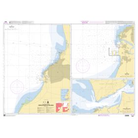
Waterways between Usedom, Berlin and Eisenhüttenstadt.
Area sections included: Peene, Peenestrom, Szczecin Lagoon, Lower Oder, Middle Oder and Oder-Havel Canal.
The inland map atlases appear in a new edition at irregular intervals of two to five years. The included BinnenKarte Digital are continuously updated and are up-to-date upon installation. Thanks to the RevierService, which is included free of charge, they remain up-to-date for one year from the initial installation.
INLAND CHARTS included :
All BINNENKARTEN are also available as laminated single sheets. The most popular BINNENMAPS from the area are listed below and can be ordered there. In addition, we have the other BINNENKARTEN available in small numbers. These are available on request.