- Out-of-Stock


Data sheet
 100% secure payments


You might also like

We endeavour to sell only the latest versions of nautical charts that include the most recent updates.
ENHD nautical charts use the meter as reference unit.
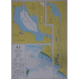
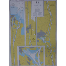
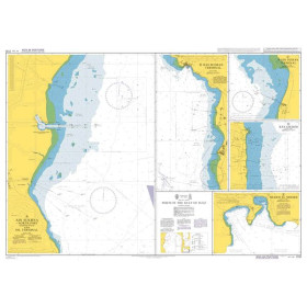
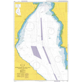
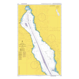
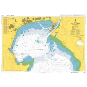
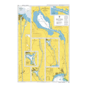
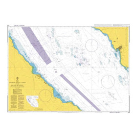
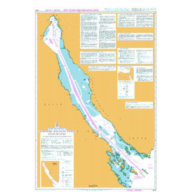
Following the establishment of the new Suez Canal, the Suez Canal Authority and the Hydrographic Department of the Egyptian Navy produced three nautical charts to help sailors navigate safely in the new Suez Canal.
Those are:
These charts are mandatory on all boats passing through the Suez Canal. Navigation in the Suez Canal must be done only with the SC1, SC2 and R11 charts.
As a result, inspections by the Egyptian Navy can be done to verify that you have on board your boat charts SC1, SC2 and R11, no boat passing through the Suez Canal can escape this obligation.
Les cartes marines SC1, SC2 et R11 à bord de l'embarcation doivent être postérieures au 6 août à 2015.
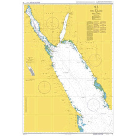
ENHD nautical charts comply with SOLAS regulations (Safety of Life at Sea) and are perfectly suitable for professional, commercial or leisure use. The charts in the series include a range of useful scales for navigation planning, ocean crossing, coastal navigation and harbour approach. Navigators should always use the largest nautical chart suited to their needs. In particularly busy maritime waterways like the British Channel, the Suez Gulf, the Straits of Malacca and Singapore, standard nautical charts are completed by itinerary guides, which provide advice for planning routes in these complex zones.
Familiar to navigators, nautical charts have undergone intensive evolution over time. Whatever chart is used, precautions must be taken for safe use. ENHD collects and continuously processes all information necessary for navigation, and then edits it, notably on nautical charts. The elaboration of nautical charts is conducted by expert cartographers who analyse, select and compile data, in order to obtain a graphical synthesis: the mapped information. They use a wide range of information: bathymetric data base, wrecks, buoyage system, undersea cables, .... and also benefit from the advice of nautical experts, geophysicians, hydrographers and a specialised laboratory for aerial or satellite image exploitation.
Keeping your chart folio up to date on a regular basis enables the integration on new information (new hydrographic data, new regulations, modifications of navigation marks or harbour infrastructure, etc.) and it also makes them compliant with international standards.
The paper:
The support of this standard nautical chart is 120 gr/m² flat paper, generally close to A0 format.
Inset:
According to the navigation zone, several insets - mainly harbours - can be found.
Both sides print:
Reprint and updates:
ENHD nautical charts are corrected daily and are only printed on request; on the day they are printed, the latest updates are included. The year of issue of the chart appears on it.